Friday, June 20, 2014

6/1/14 Northern Kansas company chase

This chase was another guided chase with my regular customer Derek. It also marked the first time that I had chased in Kansas this year. This is kind of odd, as most years I have at least several chases in Kansas and some years most of my chases are in Kansas.
We left Omaha heading for the area near the Nebraska and Kansas border south of Kearney. I was hoping for some discrete cells that would give us the best chance of tornadoes. I also had rented a wide angle lens that I was excited to be able to use to hopefully catch some good structure.
Storms fired mainly in Kansas so we headed south into Kansas for the first time this season. Unfortunately, most of the storms never really exhibited strong rotation that was anything close to producing a tornado, so we ended up just playing around with the some of the stronger storms hoping to see something cool.
At one point, a small line of storms formed that were warned for strong winds. I figured this could be a good chance to get a good shot of a shelf cloud. We headed back west a bit to the storms and were treated to a beautiful shelf cloud and it was as dark as night back behind the shelf cloud. We had some time to take some shots and were also by a railroad track so it the scene made for some good shots. Finally the storm overtook us with some gusty winds and a lot of blowing dust.
We proceeded on again heading south a bit to try and get down to the southern "tail end Charlie" storm, which normally has the best chance of a tornado. We drove into pouring rain which made the going slow. Eventually we turned east and tried to get back in front of the line. About this time the line of storms had formed a pretty good bow echo and at the top of the apex of the bow a tornado warning was issued!
We desperately tried to get back up to that part of the storm but the forward motion of the storms were around 50-55 mph so it made it hard to catch up. Soon there were reports of a tornado on the ground and some damage reports started coming in.
We eventually did make it up to that part of the storm, but by that time the storms had weakened, so we started the drive home.

 radar image of storm when tornado warning was issued and possible tornado on the ground
 
storm relative velocity showing strong velocity couplet(bright red next to bright green)
 
 first shots of the shelf cloud coming into view
 shot up the gravel road looking at the approaching shelf cloud
 shelf cloud getting closer
 some shots with the railroad track in the pic
 another shot

 southern edge of shelf cloud which had some rotation
blowing dust out along the leading edge of the shelf cloud and gust front


Tuesday, May 13, 2014

5/11/2014 Mother's Day chase in Nebraska

This day's chase didn't result in seeing a lot of tornadoes, but I still experienced a lot of action and saw one of the biggest, meanest storms I have ever seen!
Originally, this day didn't look like much of an opportunity to chase. The instability and best chance of storms was going to set up way down in eastern Kansas, Missouri, and Oklahoma. I didn't check the computer models for a few days, but decided to check them on Friday at the noon update. They looked impressive! Lots of parameters were pointing to a potential tornado outbreak on Sunday across Nebraska and Iowa!
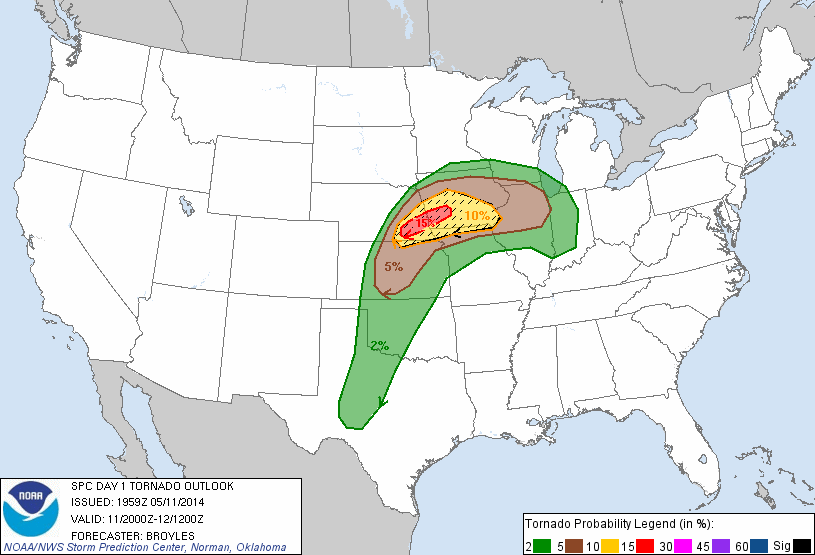
On the day 2 outlook that came out Saturday for Sunday's setup, the SPC upgraded the risk to a moderate risk with the discussion of potentially strong, long track tornadoes. The only worry was whether morning thunderstorms that were forecast to develop on Sunday morning would ruin the instability across the area.
Sunday morning I awoke to the expected thunderstorms. Some were severe with large hail across south central Nebraska and moved east across Nebraska into Iowa. At my house, I received .8" of rain.
Now it was time to hope the clouds would burn off and allow the sun to come out and create lots of instability. There was a warm front across northern Kansas that would be trying to lift north and where that front set up would be important for where the strongest storms would be. Slowly the clouds started to clear and move out throughout the late morning, especially in south central Nebraska and through the early afternoon in eastern Nebraska.
I had planned on heading out with a friend Mike, by 1-130 and head southwest towards Hastings, Nebraska. We left a little later than planned heading west around 200.
By 245, a tornado watch was issued for most of south central into eastern Nebraska. At 300, the SPC increased their odds for tornadoes and said in their outlook that there was a pretty good chance of a strong long track tornado from west of Lincoln through Omaha and into Iowa. The first cell formed south of Hastings and slowly strengthened. I was unsure if that would be the storm of the day and continued to watch and wait for something to form further east. We made it to York and headed south, making it to Geneva, Nebraska, and then headed west towards Clay Center.
We approached the storm and suddenly it came into view. From the very beginning this storm was visually amazing. Our first view of the storm provided us with lots of blowing dust and gustnadoes across the open fields. The sky was dark and swirling like crazy back in the storm.
The RFD from the storm soon overtook us with strong winds and we headed east. The storm itself was heading northeast so we had to find a way to stay close to it and move northeast with it. That meant trying to navigate the gravel roads. The roads though weren't that good from the rain that fell earlier in the day. We tried to use them but kept coming across roads that were too muddy to even try so we eventually made our way back to Hwy 81 just south of Fairmont Nebraska.
As we approached Fairmont from the south things got pretty crazy for a while. The storm was to our north and northwest and had had reports of tornadoes on the ground for quite a while, but we couldn't see any of those due to them being rain wrapped. We came up to the intersection for Hwy 6 at Fairmont and started to get blasted with RFD winds again. Mike looked to the east and suddenly saw a tornado off in the distance! This tornado was a surprise as it wasn't back in the main hook of the storm. He snapped a couple of pics before it disappeared. There was some debris blowing across the road and part of a gas station sign was ripped off.
We turned east on Hwy 6 looking for the tornado but it was gone. We got into some rain and the rain curtains kept changing directions as we drove east through Exeter and Friend! This is a sign of strong rotation directly above us.
Meanwhile the meanest part of the storm kept producing tornadoes as it moved by Cordova and Beaver Crossing heading towards I-80. Hwy 6 turned north towards the interstate so while the storm was moving east and northeast it was now gaining on us. I kept a close watch on the radar and now there was a report of a tornado near the interstate and it was moving due east now.
The scariest part of our chase occurred next as we came up to the Milford exit on I-80. The winds started screaming again from the west as the RFD started to blast us. There was again debris blowing across the road and some small branches flying through the air. The car was kind of hard to control as the winds blew across us. Right before we approached the exit I looked to the west and in the heavy precip core to our west, there appeared to be a darker column that could have been a tornado. We got to the interstate and blasted east. Shortly thereafter, there was a report of 90 mph winds at the exit!
We went east to Lincoln and went north and there had a good view of the storm to our west/ northwest. Here the storm was probably the coolest looking storm I've ever seen. It had an amazingly long inflow tail and the sky had shades of green in it.
We dropped back to the interstate to continue heading east/northeast. The storm was now becoming more "messy", and had no real hook to it and the best areas of rotation kept changing but were always imbedded in the rain and hail. We made more attempt to go north to get closer but had to turn around as the storm beat us to the highway we were heading north on.
Back on I-80, the storm started producing crazy cloud to ground lightning. We even saw several strikes hit radio towers off of the road. The storm continued on towards Omaha and the western suburb of Elkhorn. It was weakening however and soon was "only" severe warned for some hail and wind. No tornado warning was active. Soon thereafter though a tornado warning was issued and this included western Omaha.
Mike and I were now on Hwy 31/204th street heading north towards Elkhorn. The storm started to overtake us and the rain and wind was coming down hard. I was still watching the radar though and soon noticed an area of rotation west of Elkhorn. I decided to stop to let the storm move past us. After waiting for the rain and wind to let up we continued north where we started to run into some damage done to trees and road signs near Elkhorn. We continued home and everything was okay at my house, but the neighbors lost a smaller tree.
There was reports of some much more significant damage to areas in Elkhorn and the NWS has come out with a damage survey that shows 2 tornadoes touched down in Elkhorn. The 2nd tornado actually went about 2 miles northwest of our house! Wind gusts across most of the central and northern half of Omaha were 70-75 mph. An 82 mph wind gust occurred at the Omaha Eppley airport! At one point there were almost 24,000 people without power in the Omaha area.
At the time of this writing there is believed to be 11 tornadoes across south central into eastern Nebraska with a couple of the tornadoes rated EF-3.
Overall, this was a pretty fun chase with an amazing long lasting supercell. I wish we could have seen more tornadoes but again they were all mostly rain wrapped.

 Day 2 outlook
Day 2 outlook probabilities
Day 1 3pm outlook

 Day 1 3pm tornado outlook(notice the 15% hatched red area right over Lincoln and Omaha)
Day 1 3pm hail probabilities
First tornado warning near Clay Center. I am the white circle under the purple line.
 Tornado warned storm approaching Beaver Creek. Severe damage would later occur in Beaver Creek.
 Tornado over Beaver Creek. Again I am the white circle under the red box towards the bottom.
Storm moving into Omaha. The tornado was about to touch down near Elkhorn. I am the white circle in the purple box. The tornado would be right above me in the green colors. This is a notch where tornadoes can occur.

 Storm as we first approached near Clay Center, NE
 more shots of the storm as it moved northeast across south central Nebraska

 several areas of rotation on the HP storm

 storm northwest of Lincoln. one of the coolest looking storms I have ever seen!
 again
ground scraping inflow cloud into the storm!
 
The storm produced some heavy rainfall totals across most of eastern Nebraska. Some totals up to 7" were reported. Here at my house, my rain gauge measured 2.73" of rain
 
I will post some video once I get it uploaded. Here are some other clips of videos taken by other chasers on this storm.
 
 
Damage surveys from Omaha and Hastings:


Wednesday, April 30, 2014

Guided tour chase in central Nebraska 4/27/14


It's been a long time since I have posted on this blog! My last post from a chase was 2 years ago in 2012, but have gone several times since then. In 2012, if I remember correctly, I only went a couple of times. Last year was a little better but still only a handful of times with another slow severe weather season.
I will try to post a few pics from the last several chases I have been on. Some of my chases lately have been with who has become my regular customer Derek, whom I take out as part of my guided storm chase tours.
This post will be a recount of my chase on April 27th, again with my customer Derek.
 
This days chase ended up being a perfect example of why I love weather because you just never know what will happen. Originally, this day looked like there would be a huge outbreak of storms from Nebraska down to Louisiana. There was already a moderate risk issued for Arkansas and Missouri and the first day 1 outlook to come out had a fairly high risk of strong tornadoes and large hail with a possible upgrade to a moderate risk across eastern Nebraska. This was my original target leading up to the chase day. When I woke up that morning, it was raining and storming and it didn't stop until after noon. The rain and clouds killed all the instability and soon the outlook for severe storms for eastern Nebraska was greatly reduced.
I had a choice to make on where to go for a chase or whether to go out at all. There was a big line of storms that had formed late in the morning that didn't seem too appealing for tornado chances. This line went all the way from Iowa down into Kansas. Back to the west in western and central Nebraska, the skies were clear or clearing and the low pressure was sitting back there spinning. So if enough instability could develop there could be a decent chance of a tornado or two. I decided it would be worth the risk to head west.
Derek and I headed west down I-80 leaving Omaha about noon. We went as far as Grand Island and headed south on 281. An arc of storms had formed a line from NW to SE, southwest of Grand Island and had a few severe thunderstorm warnings with them. About the time we turned south though, one of the storms became tornado warned and soon had a confirmed tornado touchdown. We were still 30 minutes away though from being able to intercept it. We made it to Hastings, and a separate discrete cell had formed to our southeast now. Rather than try to go after the already tornado warned storm to our west we headed back east. I figured the discrete storm would have a better chance of producing a tornado and would be easier to track.
This new storm was heading due north about 10 or so miles to the west of highway 81. We made our way back to highway 81 and started to head back north with the storm paralleling it on the highway. The storm was pretty impressive looking, but nothing that looked really tornadic at all. It was occasionally producing hail as big as golf balls.
Suddenly in a matter of a couple of minutes a wall cloud formed out of nowhere. We were about 20 miles south of York now. This low hanging cloud below the base of the storm continued to rapidly grow. After a few more minutes it slowly started to rotate. Soon after however it fell apart. It was from this point on though that cell suddenly became a lot more interesting as it kept trying to produce wall clouds on its path north towards I-80.
We drove into York with cell still to our northwest. Again it produced a rather low wall cloud and sure enough a brief funnel and then tornado formed near Bradshaw. We jumped west a bit out of York and took a county road north to continue paralleling it. Finally at this point the cell became tornado warned.
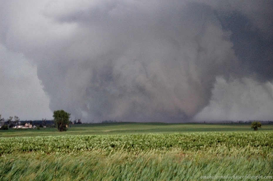
It still was pretty impressive on radar but appeared to be slowly weakening. However at one point there was a very strong rotation signature on radar, but the area of rotation was back in the rain in the middle of the cell. We had stopped at one point just watching the storm and taking a few pics when out of the rain a tornado appeared! We were just west of Osceola, NE. It lasted only for about 1-2 minutes before it disappeared again.
We stayed with the storm for about another 30-45 minutes longer before it continued to weaken to the point where we knew it was done producing any tornadoes. We headed back home just around Columbus, NE.


 developing wall cloud southwest of York
 wider shot of storm and developing wall cloud
 another shot of wall cloud
 storm trying to produce tornado west of York
 wall cloud and possible tornado developing west of York

 possible tornado?!
 beautiful shot of storm northwest of York
 suddenly a tornado appears out of the rain!
closer shot of brief tornado west of Osceola, NE
storm relative velocity showing tight area of rotation where the bright red and bright green are next to each other between the green triangle and the circle. tornado likely occurring at this time back in the rain


Monday, April 28, 2014

A quick update....

It's been a long time since I have posted here on the blog. Having a little one makes it harder to find time to do things like this!! I wanted to update the blog here briefly. First off I still chase when time and the weather allows. Last year I believe I went out about 5x or so. This year(2014) I have gone out a couple of times.
I still have my "company". I have decided not to offer group tours at this point. The logistics and everything needed to be able to do that and be successful is just too much to do at this point. However, I still am doing individual tours. I plan on continuing to take out 1-3 people at a time in my vehicle for a fee. Please contact me at greatplainstornadotours@yahoo.com if you are interested. Thanks!

Sunday, April 22, 2012

Video from 4/14/12 chase!

I have edited/finished the video from the first Great Plains Tornado Tours chase last weekend! As a side note, the video was recorded in HD, so make sure you choose to watch it in HD on Youtube by clicking on the "change quality" button along the bottom of the video(looks like a flower), and selecting 1080p for the quality. Looks MUCH better! Enjoy!

Solomon, KS tornado!

Sunday, April 15, 2012

First company chase! 4/14/12 Kansas tornado

This day was my first guided tour chase that I did as part of my company. Mike, my first customer, an old college buddy, Jerry, and myself headed out on what was expected to be a huge, possibly deadly tornado outbreak. A rare day 2 High risk outlook was issued for the large storm system that would be moving through the Central Plains.
We left Omaha later than we wanted to, around 230 and headed west on I-80. Morning and early afternoon thunderstorms were slow to clear out and were killing instability and also the placement of a warm front that was expected to lift north through Nebraska. We made it to York, NE and then headed south towards the Kansas border. When the atmosphere still hadn't recovered by 430, we decided to keep going south into Kansas and hopefully catch one of the intense long track tornado producing supercells that were moving northeast out of central Kansas.
One cell southwest of Salina, had a tornado on the ground for over an hour as we headed towards it and I-70. We were within 30 miles or so of the storm when it suddenly started to fall apart. We continued on though hoping to get some good structure shots at least. All of the sudden, the storm re-intensified and began to look again on radar as we approached it. The base came into view and there was a large bowl shaped funnel most of the way to the ground to our southwest near the town Solomon, KS. By the time we found a good road to pull off of the highway onto, the funnel had dissipated but a rapidly rotating wall cloud persisted.
We watched the wall cloud for a while as it slowly weakened. We wanted to get closer to the storm and saw a road a couple of miles down the road to the west off of I-70. Just as we got back to Hwy 15, the storm rapidly formed a funnel, so we stopped again to take pics and video. The funnel quickly formed into a tornado that widened into a stovepipe. We stayed there and watched it move rapidly northeast for the next 5-7 minutes or so. It started to rope out as it moved away to the north and we finally jumped down to the interstate to move back west down to the next exit. We turned north at the Solomon exit and the tornado strengthened briefly before again starting to rope out. This time it roped out for at least another 5 minutes!! It was beautiful to see! We stopped for some pics after getting closer again, waiting for it to finally die. It gave us one last cool image as the middle part of the tornado dissipated but the part along the ground persisted for another 45 seconds or so.
We then headed home as it was nearly dark and dodged some more severe storms that mainly had hail and high winds. It was a little tricky at times though as these new storms were now moving at 55-70 mph!
It was a very successful first chase, as both Mike and Jerry saw their first tornadoes ever!

rapidly rotating wall cloud near Solomon, KS
structure shot of supercell

tornado just touching the ground

Mike taking pics of his first tornado
Jerry taking pics of his first tornado

tornado strengthening

close up shot of tornado near Solomon, KS
another zoomed shot of tornado

nice shot of large tornado

tornado roping out near Talmage, KS

Tuesday, April 3, 2012

First post

I've decided to create a separate blog for my storm chasing company. I will post updates here in regards to the company and will also put on chase recounts from the tours we provide. I also plan on putting up some of my greatest chases here from the times that I went out not on a company chase! Hopefully, this blog will stay active!!