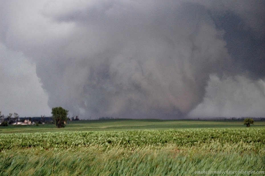
If I had this one to do over...... Today was a day that every chaser dreams about and wishes they were there/ regrets that they didn't go, me included. Originally, this day looked like it was going to be a good chance to go chasing relatively close to home in central nebraska. with each successive model run though the best ingredients were coming together further and further north. i hadn't been chasing in a couple of weeks, so i thought i will still go. it was a saturday, and chase season is already down to about 6 weeks left. i went to bed thinking i would have to go up west of yankton further in s. central south dakota. when i woke up saturday morning though, the best area looked to now be north of pierre, in fact i set a virtual target of right around gettysburg, sd. i still almost wanted to go with the idea that after a seven hour drive and chasing, i would at least have a place to stay if i ended up around home before driving back to omaha on sunday. alas though, i decided to sit this one out. the potential was there with some of the best ingredients seen anywhere in the plains this spring, however there was still some concern of the cap. throughout the afternoon i kept checking things and became increasingly worried about what could happen in northern south dakota. the storm prediction center raised the tornado probabilities and also added a hatched area, which means the potential of strong tornadoes. finally around 430-445, the first blips showed up on radar around akaska, sd about 20 miles northwest of gettysburg! i watched the storm explode on radar and within 30 minutes, the storm was tornado warned. i had to leave home for about 30-45 minutes and came back to a monster supercell on the radar with a huge hook, located west of bowdle, sd. reports were coming in of a large, dangerous tornado on the ground. i was able to watch it live on streaming video and it was extremely large! the storm went on to produce tornadoes over the next roughly two hours, producing 7 separate tornadoes. luckily, the large, violent tornado went one mile north of bowdle and all the other tornadoes missed any major towns. the bowdle tornado was rated an EF-4!! i've included links to info and pics as well:
damage survey results:
http://www.crh.noaa.gov/product.php?site=abr&product=pns&issuedby=ABR&format=CI&version=1&glossary=0my favorite part of the damage survey:
TWO LARGE GARAGES WERE COMPLETELY DESTROYED WITH THE
CONCRETE SLAB WIPED CLEAN. THE VEHICLES IN ONE GARAGE WERE
ROLLED/TOSSED FROM 25 TO 100 YARDS AWAY. IT IS ESTIMATED THAT ONE
VEHICLE FLEW THROUGH THE AIR 75 TO 100 YARDS RESTING IN THE TREE
SHELTER BELT TO THE NORTH OF THE RESIDENCE.

LOCATED JUST NORTH OF THIS RESIDENCE...SEVERAL METAL POWER
TRANSMISSION TOWERS WERE TOPPLED. ONE TOWER WAS SHEARED OFF FROM
THE CONCRETE FOOTINGS AND TRAVELED AN ESTIMATED 400 YARDS AWAY.
THERE WERE 6 TO 8 OF THESE TOWERS TOPPLED. GROUND SCOURING WAS
VISIBLE ALONG THE PATH OF THESE TOWERS. THE DAMAGE TO THE TOWERS
IS CONSISTENT WITH AN EF4 TORNADO RATING WITH WIND SPEEDS FROM
166 TO 200 MPH.

more info on the tornado:
http://www.crh.noaa.gov/news/display_cmsstory.php?wfo=abr&storyid=52954&source=0some of the amazing pics, videos, and stories of other storm chasers that were there:
http://stormtrack.org/forum/showthread.php?t=24152few videos off of youtube:
http://www.youtube.com/watch?v=GGqINBsCPFghttp://www.youtube.com/watch?v=jiYY6uisMYohttp://www.youtube.com/watch?v=8U8FK47vfzAradar grabs:


