It's been a long time since I have posted on this blog! My last post from a chase was 2 years ago in 2012, but have gone several times since then. In 2012, if I remember correctly, I only went a couple of times. Last year was a little better but still only a handful of times with another slow severe weather season.
I will try to post a few pics from the last several chases I have been on. Some of my chases lately have been with who has become my regular customer Derek, whom I take out as part of my guided storm chase tours.
This post will be a recount of my chase on April 27th, again with my customer Derek.
This days chase ended up being a perfect example of why I love weather because you just never know what will happen. Originally, this day looked like there would be a huge outbreak of storms from Nebraska down to Louisiana. There was already a moderate risk issued for Arkansas and Missouri and the first day 1 outlook to come out had a fairly high risk of strong tornadoes and large hail with a possible upgrade to a moderate risk across eastern Nebraska. This was my original target leading up to the chase day. When I woke up that morning, it was raining and storming and it didn't stop until after noon. The rain and clouds killed all the instability and soon the outlook for severe storms for eastern Nebraska was greatly reduced.
I had a choice to make on where to go for a chase or whether to go out at all. There was a big line of storms that had formed late in the morning that didn't seem too appealing for tornado chances. This line went all the way from Iowa down into Kansas. Back to the west in western and central Nebraska, the skies were clear or clearing and the low pressure was sitting back there spinning. So if enough instability could develop there could be a decent chance of a tornado or two. I decided it would be worth the risk to head west.
Derek and I headed west down I-80 leaving Omaha about noon. We went as far as Grand Island and headed south on 281. An arc of storms had formed a line from NW to SE, southwest of Grand Island and had a few severe thunderstorm warnings with them. About the time we turned south though, one of the storms became tornado warned and soon had a confirmed tornado touchdown. We were still 30 minutes away though from being able to intercept it. We made it to Hastings, and a separate discrete cell had formed to our southeast now. Rather than try to go after the already tornado warned storm to our west we headed back east. I figured the discrete storm would have a better chance of producing a tornado and would be easier to track.
This new storm was heading due north about 10 or so miles to the west of highway 81. We made our way back to highway 81 and started to head back north with the storm paralleling it on the highway. The storm was pretty impressive looking, but nothing that looked really tornadic at all. It was occasionally producing hail as big as golf balls.
Suddenly in a matter of a couple of minutes a wall cloud formed out of nowhere. We were about 20 miles south of York now. This low hanging cloud below the base of the storm continued to rapidly grow. After a few more minutes it slowly started to rotate. Soon after however it fell apart. It was from this point on though that cell suddenly became a lot more interesting as it kept trying to produce wall clouds on its path north towards I-80.
We drove into York with cell still to our northwest. Again it produced a rather low wall cloud and sure enough a brief funnel and then tornado formed near Bradshaw. We jumped west a bit out of York and took a county road north to continue paralleling it. Finally at this point the cell became tornado warned.
It still was pretty impressive on radar but appeared to be slowly weakening. However at one point there was a very strong rotation signature on radar, but the area of rotation was back in the rain in the middle of the cell. We had stopped at one point just watching the storm and taking a few pics when out of the rain a tornado appeared! We were just west of Osceola, NE. It lasted only for about 1-2 minutes before it disappeared again.
We stayed with the storm for about another 30-45 minutes longer before it continued to weaken to the point where we knew it was done producing any tornadoes. We headed back home just around Columbus, NE.

developing wall cloud southwest of York

wider shot of storm and developing wall cloud

another shot of wall cloud

storm trying to produce tornado west of York

wall cloud and possible tornado developing west of York


possible tornado?!

beautiful shot of storm northwest of York

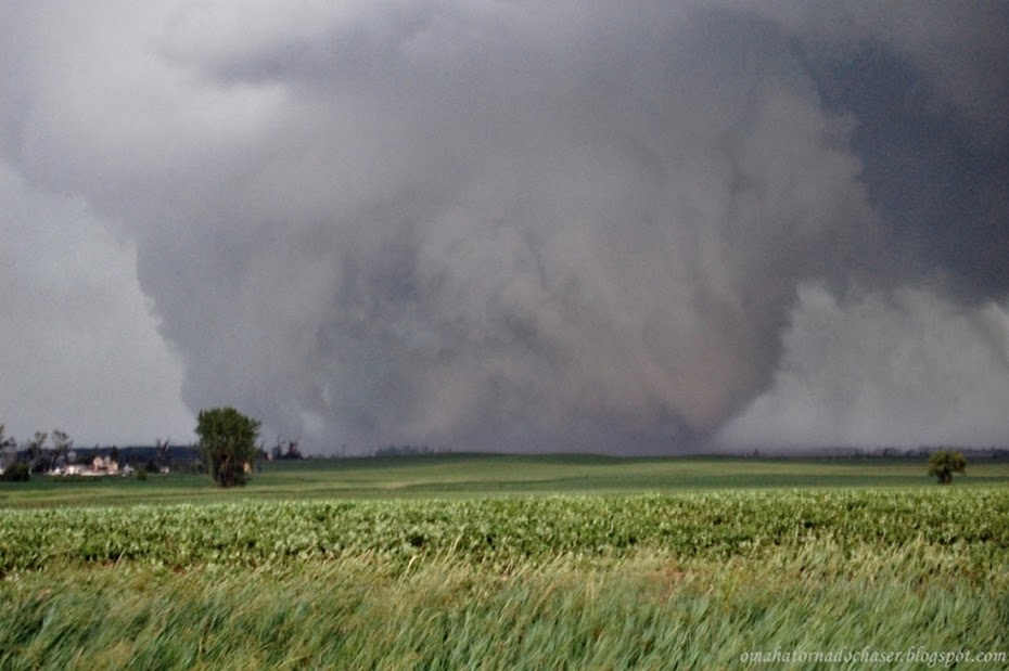
suddenly a tornado appears out of the rain!

closer shot of brief tornado west of Osceola, NE

storm relative velocity showing tight area of rotation where the bright red and bright green are next to each other between the green triangle and the circle. tornado likely occurring at this time back in the rain