We headed west down I-80 to Grand Island and then went south into northern Kansas. On the way down there a storm formed early and quickly became tornado warned with a confirmed tornado that went near a town in northern Kansas. We were hoping we didn't just miss the only tornado of the day.
The storms that were forming thereafter weren't initially real organized or isolated, there were a lot of clusters of storm, usually with nothing really standing out as a dominant storm. Another storm became tornado warned and we had to take a roundabout approach to get to it, and by the time we did the rotation weakened.
We were chasing around the Hwy 36 corridor in northern Kansas in the area of Mankato. We were headed east on Hwy 36 when finally a more isolated cell formed to our east moving almost due north to the east of Mankato. We went after the storm but it tracked away from us pretty quickly. We were now between the area of Formosa and Courtland Kansas when a base of a storm came into view to the southwest of us. We had pulled into a parking lot of a business along the highway and had this view of the wall cloud:


The wall cloud briefly had a tornado touch down. First tornado of the day! This storm was also moving north and passed the highway to our west. We continued to watch it though and soon another tornado formed. At one point the initial area of circulation with a tornado on the ground was weakening while a new area formed and a second tornado formed and was on the ground at the same time! We didn't get a chance to snap any pics, but we followed the storm north up Hwy S266 towards Republic, KS. The tornado stayed on the ground for at least 5 minutes. Here was our view:


While we following this storm north, I had my eyes on the radar and a storm that was approaching from the south almost on the same path, but just slightly further east. This storm was the best looking storm of the day and I was sure was going to produce a tornado. This storm's path though was going to take it right towards us and the highway we were on.
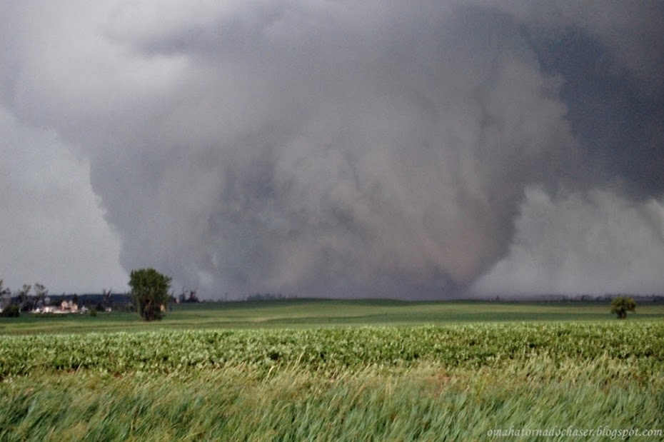
I knew we would have to turn around and go back south to Hwy 36 so we could get east of the storm and have a good view of it. Also I wanted to make sure we had a good east/west road to stay safe. Luckily, the tornado we were chasing finally lifted and we were able to race back south towards Hwy 36. We just barely beat the storm back to the highway running into some quarter sized hail. Once we made it to the highway and went east a mile or two, we could see the base of the new storm coming from the south. It had a huge wall cloud and looked like a tornado could form at any second. We found a gravel road to head south towards the storm. We drove about a mile or so south past an ethanol plant and some trees and the storm was in clear view and very close! There was a huge rotating wall cloud with a not quite fully condensed tornado underneath. There were multiple vortices swirling underneath the storm kicking up dust in the field.
We stopped to grab some pics and my video camera was rolling. However, when we opened the doors the warm, humid air caused my video camera lens to fog up. We only stopped for about a minute or so to watch the developing tornado in the field about a mile or so southwest of us. The storms were usually moving due north this day, but it seemed like the tornado had a bit of a northeast motion to it so I wanted to drop south some more to make sure we weren't in it's path.
We pulled south about a mile or so further and then stopped to watch. While driving the tornado hit some powerlines and a building of some sort as we saw powerflashes and some debris in the air.
When we got out of the car, you could hear the tornado roar!! It was moving northeast now and we were probably less than a 1000 feet away from it. It was the closest I have ever been to a tornado! When we were first stopped, there was strong inflow of probably 30-40 mph getting sucked into the tornado. As the tornado continued moving northeast, we were now looking to our northwest at the tornado and the winds began to come from the other direction as the RFD started blasting us at 50-60 mph or more. I was somewhat worried about the powerlines along the road possibly getting blown down.
The tornado while initially not fully condensed when we first came up to it, was now growing rapidly into an intense wedge tornado. We were beginning to get hit with rain so we got back in the car and turned around to watch it. It hit the ethanol farm and cattle farm that we drove by on our way to the tornado. The tornado was very impressive and the base of the clouds above it were nearly on the ground. When we knew it had crossed the road in front of us we began to follow it, but soon came across downed power lines and a local resident that also had their way down this road blocked.
We talked briefly to the local and then turned around and found another road to get back to the highway. This tornado ended up staying on the ground for 37 miles all the way into southern Nebraska! The highest rating given was an EF-2 for the damage it did to the ethanol plant. It seemed and looked like it was a much stronger tornado though. We decided to try and catch back up to it but had to take a long route around and it took some time to get near the storm again. We managed to still see two more brief tornadoes from this storm though.
This day ranks up there with the Pilger twin tornadoes last year and the first day I ever saw a tornado, the Minnesota tornado outbreak in 2010 when I saw 7 that day.
It's days like this that I live for when I go storm chasing!
Link to my video I took. Make sure to change the settings in YouTube to HD to watch the video in the best quality! Courtland Kansas tornado
Pics of the tornado


The storms lasted well into the evening and overnight and trained over the same areas. Lincoln, NE received over 7" of rain with some parts of southeast Nebraska receiving over 10". At my house we had over 4" of rain. There was record flooding in parts of the state as well.
