Sure enough the SPC issued another moderate risk across Nebraska and into Iowa. A warm front was forecast to lie across the states, setting the stage for another similar set up to the Mother's Day outbreak. Besides tornadoes and very large hail, there was also talk of a derecho, which is a long lived line of very strong wind producing storms. Some of the wording out of the local weather offices was very concerning. The set up was potentially even more explosive than the outbreak on Mother's Day when several strong tornadoes touched down along with large hail, wind, and flooding rains.
This day's set up the offices talked of baseball or larger hail, strong tornadoes and wind over 70 mph!
Derek, Mike, and I wanted to make sure we were in position plenty early, so we left town early with an initial target of Albion, NE. We leisurely made our way west throughout the late morning. Meanwhile, an early morning storm that had formed around daybreak in southwest South Dakota continued trekking east/southeast just across the border into northern Nebraska. It gained strength throughout the morning and soon was warned for 100 mph winds and golf ball sized hail in north central Nebraska!
We briefly entertained the idea of heading north a bit to get a good look at the storm as I am sure it had some amazing structure, but decided to stay south of it. Eventually the storm started to head southeast and towards Omaha. Almost the entire time it was warned, it was warned for baseball sized hail and 70-80 mph winds. Reports coming in usually confirmed this as it moved through Norfolk and several other smaller towns.
Blair was soon the next town in the storms path, and the town was absolutely destroyed by the very large hail and high winds. The Woodside car dealership had several thousand cars damaged or destroyed with damage estimated at 10 million dollars! The courthouse was severely damaged. Other houses and vehicles were damaged as well and there were over 2 dozen minor injuries in Blair. The storm moved southeast from there just clipping northern Omaha and the airport. Winds and hail continued on into Iowa and the Omaha airport was closed for several hours.
Meanwhile back to the west, we continued to drift west, while I watched the radar for signs of initiation. Some of the severe indices were off the chart as well! Finally around 3 pm, the first returns showed up on radar near Burwell and Taylor Nebraska. We were only about 20 miles away! The storms slowly grew and became more organized until finally a dominant cell formed west of Burwell. It soon showed very large hail and developed a hook echo!
We made our way to get into a good position to try and see the base of the storm. It became as dark as night as we got closer to the storm. A tornado warning was issued! We made our way west out of Burwell on highway 91. We couldn't see a wall cloud or any real strong rotation, but the storm looked so mean! The storm while it was organizing was pretty much stationary, but as we pulled up to it, it started it's forward motion at 45-50 mph.
We soon realized we had to get moving back to the east away from the storm. We went back to Burwell and then southeast towards Ord. One thing that was immediately odd was that the tornado warning box which showed up on my radar program was quite a ways south of where the storm was on radar and the storm was moving east.
We made it down to just outside of Ord and got out of the car to look at the storm behind us. According to the radar the storm should have been several miles to the north of us, but instead was almost on top of us again! In fact it was raining almost right away where we were and the radar showed no precip should be falling at our location. We again jumped back into the car and continued heading southeast down Hwy 11. Eventually, we made it to Hwy 22 which went east to Hwy 281. Reports of a tornado on the ground were coming in but it wasn't possible to see as the tornado was rain wrapped.
We dropped south on 281a bit so we could keep heading east on 22. At this point the storm was still tornado warned and again on radar looked to be at least several miles north/northwest of us. As we headed east towards Fullerton Nebraska, we could see ahead quite a ways to the east. Soon I noticed a lot of blowing dust and dirt started to blow across the road in front of us from north to south. The wind was strong enough that the dirt was getting lifted into the air fairly high, and there was a lot of debris being blown across the road. I don't mind dirt and pieces of corn stalks but what became worrisome was there were groves of trees along the north side of the highway and soon decent sized branches were getting blown down. I was worried that something bigger could come down. A few times visibility went down to several feet for a brief few seconds. Winds were estimated at 60-70 mph. It was a little nerve racking and again surprising because the storm looked to be quite a ways away from us on radar still.
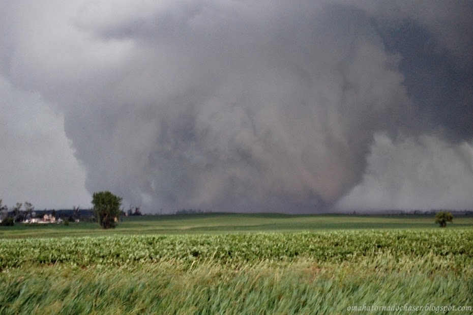
We made it to Fullerton and headed south to try and get even further south of the storm. We hadn't made it more than a couple of miles outside of town when again we noticed a lot of dust being picked up in the fields to the west side of the highway in front of us to the south. Only this time, what really peaked my interest was that there was a pretty broad area of rotation out in the field and the dust was rising pretty quickly. Up in the clouds was a pretty noticeable area of rotation. A tornado was forming right in front of us, not more than a couple of hundred yards away from the road! At this point I had the choice of slowing down and letting the circulation pass the road in front of us or try to beat it across the road. The tornado was weak and moving fairly slowly to the east so I thought it would be best to try and beat it across the highway. I didn't want to stop where we were because I was worried about the storm approaching us at 50-60 mph that was warned for baseball hail and 70 mph winds.
As we moved south down the highway dust was blowing from west to east across the road, but soon inflow winds developed near the circulation/weak tornado and winds were now screaming from east to west across the road, again with blowing dust and other debris from a nearby building.
We made it to the area of blowing dust that was the worst and suddenly visibility dropped to literally zero! I have been in blizzards and never seen visibility this bad. What was so scary about this was being on a highway, only able to drive about 5 mph tops, and not knowing if someone is going to come flying up from behind and slam into us. Also, there was a truck in front of us that went into the dust storm first and we had no idea where it was.
The zero visibility lasted about 90 seconds to 2 minutes before we finally made it into the clear. We continued on to the next east west road and initially made an attempt to go east only to see blowing dust was already approaching the road in front of us. At this point, I decided to call off the chase, as the radar still wasn't accurately showing the very dangerous storm, the storm if it was producing a tornado, it was rain wrapped, and the storm motions were 50-60 mph.
We dropped down to I-80 at York and headed east towards Omaha. This entire time storms kept forming and were heading east over the same areas north of the warm front that ran from north central Nebraska southeast to just south of Omaha and into Iowa. The Omaha Eppley airport reported over 5" of rain and there was flash flooding in northeast Omaha. The last storm we ran into was a severe storm that crossed I-80 near Ashland. It had reports of golf ball to baseball sized hail and we were just behind it so we didn't run into any of that.
After all the storm reports came in there were only a handful of tornado reports, and only a couple of confirmed weak tornadoes. Most of the storms and especially the main, big storm that we were chasing ended up being a bit elevated as they were just too far north of the warm front. However, there was a ton of large hail reports up to softball sized and lots of high wind reports as well.
I posted a question on a chasing blog that I frequent asking if anyone else had issues with the radar program that I use. Other users of the same radar program also said they had similar problems with the radar not matching up with what the storm was doing and where it was located. I haven't heard any reasoning for why this happened.

storm reports from the day- Nebraska was the place to be!

day 2 outlook- already a moderate risk

day 2 probabilities

Day 1 outlook at 1130am
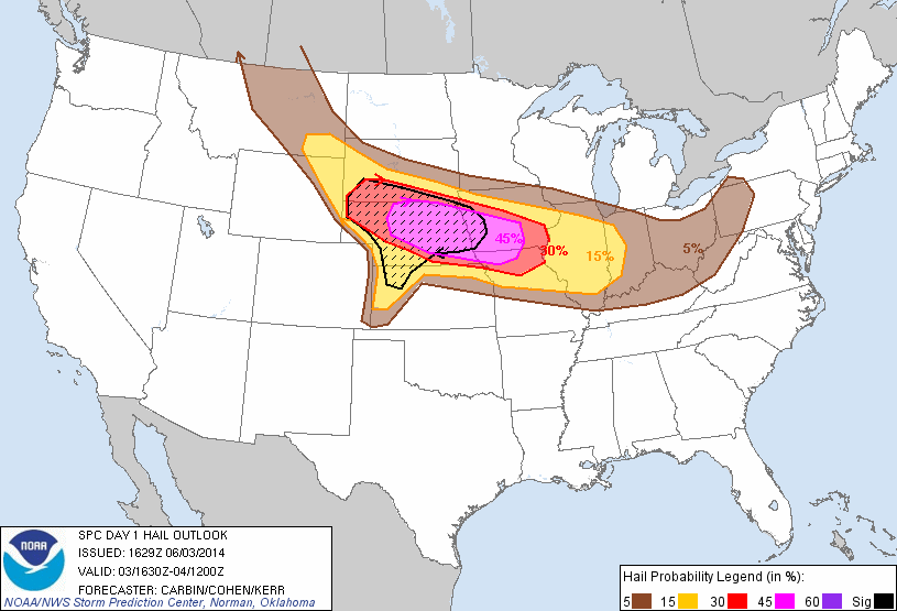
hail probabilities

tornado chances- 10% hatched area for possible strong tornadoes

wind probabilities

radar image of the storm we were chasing taken from around 4pm

tornado warned storm we were chasing now about 6pm

first storm developing north of Ord

the main storm as we approach it west of Burwell

the tornado warned storm made it dark as night at 4pm

the storm still tornado warned but not able to see the tornado

Mike, Derek, and I stopped for some pics after the first time driving through the high winds and blowing dust

My customer Derek taking pics of the storm after our 2nd close call. You can see the blowing dust out in front of the storm on the right hand side

Pic of the tornado as it was starting to form just off of the highway in front of us!


