I have finally bought the equipment needed to be able to transfer over my video from my camera to my computer so I can edit and upload the content.
My first chase that I wanted to upload and edit was of course my video from this day's chase. I had almost 60 minutes of video recorded from this day that I have cut down to about 27 minutes.
A couple of observations:
1) The video definitely isn't some of my finest. There are times where I am thinking, what the heck was I doing there when the camera shot is not pointing anywhere close to the tornado? I guess I was just trying to do a million things at once, including times where I was trying to take still pictures as well as video.
2) I have seen tons of other videos from this day and a lot of them have closer shots of the tornadoes. I then immediately get disappointed that I didn't get closer. It's funny though, when everything was happening on this day, I don't ever really remember thinking I wasn't close enough or I need to get closer. I felt like I was close enough. I don't know if it was a conscious decision to not get closer because I didn't want to feel any more unsafe or not. It seemed like tornadoes and circulations were wanting to form almost anywhere under the storm. Another possible thought that was probably in the back of my mind was of the chasers that were killed in 2013 from the El Reno tornado. Dying while chasing isn't something I really want to do!
So with all that being said, here's the video. Make sure to switch the video settings to 1080p for HD if the video doesn't automatically start playing that way. Enjoy!
Pilger twin tornadoes
Welcome to Great Plains Tornado Tours!! Here I will keep updates on my company and also post updates from recent chases.
Tuesday, November 11, 2014
Sunday, July 20, 2014
6/16/2014 chase: Nebraska Tornado Outbreak and Twin Tornadoes!!
This chase will be a day that I am sure I will remember for the rest of my life and might end up being the best chase I ever will have! Before today, my career chase day was June 17th, 2010 in southern Minnesota. That day I saw my first tornadoes and ended up seeing somewhere around 6-8 tornadoes, including an EF-4.
This day was another moderate risk in eastern Nebraska and into Iowa with a warm front draped across the area and a strong piece of energy moving across the area that provided an increase in the wind fields thus increasing the low level shear.
The day started out with some morning severe storms that dropped large hail up to baseball sized as they moved northeast from southern Nebraska into western and northern Iowa. The storms cleared eastern Nebraska around noon and most of them weakened. Initially, the area that was focused on for more robust development in the afternoon was into Iowa. I watched the storms closely as they weakened and I headed out of my house and towards I-29 heading north around 12:30. There was one final storm that was moving towards Harlan that briefly looked like it could be a storm to follow but suddenly, it quickly weakened. I continued north watching more storms already up near Sioux Falls and into northwestern Iowa, but those were in a large cluster and didn't seem real conducive for tornadic development. I made it up to Onawa, Iowa and there were initial signs of development back to the west near Norfolk, Nebraska. I made a quick pit stop and decided that would be my target to go after. Skies had mostly cleared in that area and instability and wind shear were quickly increasing. Soon a mesoscale discussion was issued for northeast Nebraska and the 3pm update on the SPC upped their probabilities of tornadoes to a 15% hatched area for potentially strong to violent tornadoes!
As I headed west, the skies cleared and soon I could see the large cumulonimbus cloud and anvil of the storm to my west. It was a very impressive storm visually from the moment I saw the storm 40-50 miles away. Fairly soon a PDS tornado watch was issued for northeast Nebraska. "PDS" is short for "Particularly Dangerous Situation" and these watches are only issued a handful of times each year when there is a potentially explosive environment in place for possibly deadly storms.
I approached the storm on Hwy 275 heading west. The storm was now severe warned as it continued to grow southwest of Stanton, Nebraska. I took Hwy 57 south through Stanton and then west on Hwy 32 for a couple of miles. The back end and base of the storm came into view and I found a gravel road to pull off of to watch the storm. I had a great view and soon a wall cloud formed. It didn't take long for the wall cloud to start rotating and a funnel to form. It was cool to watch the tornado form as small individual circulations briefly appeared in the field below the funnel. Soon a fully condensed funnel formed and touched all the way to the ground. This first tornado only lasted a minute or two before it lifted but it was easy to see the storm wasn't done. Another tornado quickly formed and became a grayish-white stove pipe tornado on the ground.
The storm was moving off to the north and east now and was beginning to get out of my view. I hopped into my car and drove back the way I came towards Stanton. Unfortunately, the views weren't great due to hills and trees as I tried to look off to my northwest, but it was beginning to look like there could be a large rain wrapped tornado on the ground. I made my way through Stanton still heading north. I was just going through the last turn in town when the power lines in front of me began throwing out sparks! The tornado was probably a good 3-5 miles away from me as I drove north out of town. I finally got a clear view of the storm and it almost took my breath away! It was a large rain wrapped tornado just like I thought. However, what was so amazing was it looked like the whole storm was rapidly rotating to the point I could easily see it. Not just the tornado and the rain curtains under the base of the storm was rapidly rotating, but it looked like the clouds above it all the way up to the top of the storm were rotating rapidly too. It was an amazing sight to see!
I cautiously moved further north and found a good spot to stop and take pics and video. I got out of the car and could hear the tornado roar! I started taking pics and video and I looked to my east and another tornado was forming! I got back in the car and headed a couple more miles north to Hwy 275. As I came up to the highway, I began to come across damage. There was a bunch of debris in the power lines and also the road was pasted in mud and other debris. The wedge to my north looked less organized and now a skinny white rope had come out of the rain. The wedge was beautifully roping out! I headed east watching the new tornado forming ahead of me and quickly another new funnel was forming near this new tornado. Tornadoes were forming everywhere!
I proceeded east on Hwy 275 watching as the second funnel forming soon became a large, mean looking tornado while the first one continued on the ground. Two, violent tornadoes were on the ground at the same time and within a mile of each other! It was an amazing sight to see and I could hardly control my excitement. It's not necessarily that uncommon to have 2 tornadoes on the ground at the same time, but usually this involves one large tornado and another smaller satellite tornado moving around it. But this was 2 individual violent tornadoes that were acting and moving independent of each other. I kept driving on to the east as the 2 tornadoes were moving northeast across the highway in front of me. I would drive a ways, stop and take pictures, and then continue on for a few minutes before stopping again. It was weird but I never thought about getting closer( I think I thought I was close enough), but after seeing some of the videos and pics come out, I sometimes wish I would have drove faster to get up closer to the tornadoes. I think in the back of my mind, I was playing it safe remembering the chasers that were killed last year on a violent tornadic storm.
The tornadoes moved north of Hwy 275 and one of them lifted for a while before forming again. Again there were 2 large tornadoes on the ground! I soon came across the damage path where the tornadoes crossed the highway. I was so focused on the tornadoes to my left(north), that I only noticed the damage to a large cattle farm on the north side of the highway. I didn't notice the town Pilger that had been hit 1 mile south of the highway. The tornadoes were moving off to the north and I would have liked to have been able to turn north with them, but was worried about the roads so I continued east on Hwy 275 for a bit longer and then jumped east on Hwy 51 north of Wisner. A ways down the highway I found a great spot to view the storm to my north. At this point, both tornadoes had lifted, but there was still a large wall cloud. Shortly thereafter, a large wedge tornado started to form and another skinnier tornado formed next to this one. 2 tornadoes on the ground again! This time the second tornado was a satellite tornado and I watched as the smaller one circled around the larger and dissipated. Again though the storm was heading off to the north and I had to find a way to catch back up with it. I took Hwy 9 north through Pender and towards Emerson. There were reports of a tornado still on the ground and this would be the EF-4 Wakefield tornado. I believe this tornado was rain wrapped most of the time as I did get close enough to the storm but wasn't able to see any tornado. I took Hwy 35 northeast towards Sioux City and the last report of a tornado was near Jackson, Nebraska. I did visually see this tornado as it was a weaker tornado that didn't last long before it lifted. The storm was rapidly weakening now luckily as it moved towards Sioux City. In fact I was pretty amazed at how quickly it died. I called off the chase at that point in Sioux City at about 6:00 and started to head home.
As I was heading home down I-29, I decided to take a look at things elsewhere to see if any other tornadic storms or severe weather was going on in the area. Way back to the west in central Nebraska, a monster storm had formed and soon a tornado warning and confirmed tornado was on the ground. It was in an environment and moving towards an area where the storm would be able to likely maintain it's strength and possibly keep a tornado on the ground. I decided with the long daylight of June and plenty of time still left in the day, I would head west towards the storm for a while to see what happens and if the storm weakened I could still turn back to the south and head home. I actually ended up taking the same exit at Onawa and was soon traveling down the same roads I had been on earlier in the day.
The tornadic storm in central Nebraska still had a tornado on the ground as it moved slowly northeast at about 20 mph quite a ways southwest of Norfolk. I continued onto the west and it looked like I might make it to the storm around 9pm. Soon however, I approached the area where the twin tornadoes had crossed Hwy 275. This time I was going to make sure to look to the south side of the highway to see what I could of the damage in Pilger. I believe at that time I had already heard of the 2 fatalities in the area from the tornadoes. I came up to the highway that leads to Pilger one mile south of Hwy 275. The traffic was stopped and there were lots of highway patrol and media and other emergency vehicles at the intersection and on the road into Pilger. I had time to look to the south and could see tons of damage even though I was one mile away. I could tell the damage was severe. I continued onto the west and came up on the second damage path from the rain wrapped wedge tornado that first formed west of Stanton. Here there was a lot of debris in the trees and some power lines. There was also a section of the highway where a rather large section of power lines were across the road. A highway patrolmen was there directing traffic carefully through the damage. As I slowly crept along the highway, I looked to the north side of the road and noticed a severely damaged vehicle lying in the ditch. This car was actually almost unrecognizable. The only thing that was left was the front two tires, the bottom frame of the vehicle and part of the cab frame. The engine, rear wheels, and all the metal and stuff in between the frame was gone! I drove for a while longer towards Norfolk, but was no longer in the mood to see another potentially large and dangerous tornado, so I headed home.
All told there were 4 EF-4 tornadoes produced by this single storm. Estimated winds with these tornadoes were up to 200 mph. 2 people died, 1 young child in Pilger, and another gentleman who was driving when his car was hit also near Pilger. There was an initial storm survey that came out several days after the tornadoes, but as of this writing I haven't seen the normal more detailed report that comes out from the NWS. I might send them an email asking them about it. Here is the report that has been released.
Of course, there were many chasers out there and tons of amazing video and pics that have come out. Here are a couple of my favorite videos: This guy looks like he is going to drive right into the tornado. Another video shows the tornado going through town with the grain bins flying through the air and even what looks like an entire house flying around the base of the tornado! Of course any search online will result in numerous videos to watch. Unfortunately, right now I don't have a way of uploading my video onto my computer to show what I captured from this day. Hopefully soon, I will be able to transfer over my video from my video camera.
Now onto my pics and images!
Day 1 morning outlook showing moderate risk again!
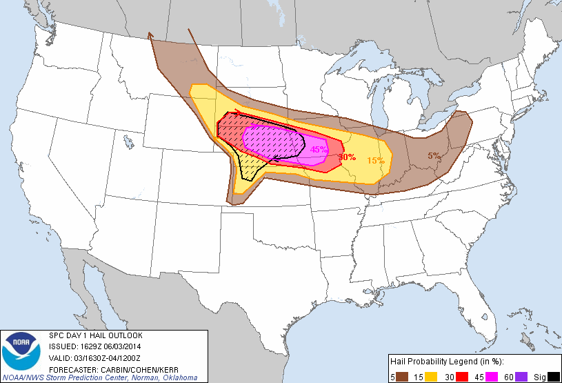
Day 1 hail probabilities- potential for very large hail
Day 1 morning tornado probabilities with hatched risk for strong tornadoes
Day 1 morning wind probabilities
Day 1 3pm afternoon update with moderate risk
Afternoon update hail probabilities
3pm update now showing 15% hatched area for strong tornadoes!
Afternoon update wind probabilities
Storm reports for the day
First view of the storm from probably 40-50 miles away! Perfect structure!
Wall cloud forming on the storm southwest of Stanton
First tornado touchdown!
Dust whirls beneath the tornado
Tornado on the ground again moving away from me
Violent wedge tornado north of Stanton. I could hear it roar!
Closer shot of the wedge
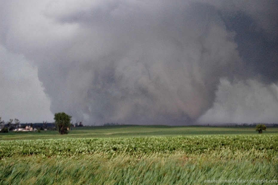
The Pilger tornado on the ground!
Twin tornadoes! The one on the left was the tornado that moved through Pilger. The one on the right is the new one
The tornado on the left has temporarily weakened
Closer shot of the stronger tornado on the right
One of my favorite shots!
Second tornado reforming
2 on the ground again!
The new Wakefield tornado forming with a satellite tornado on the ground too!
Violent wedge on the ground. This is the Wakefield EF-4 tornado
Wakefield tornado moving away from me. Should have tried to stay closer
Possible tornado back in the rain
new area of rotation forming overhead
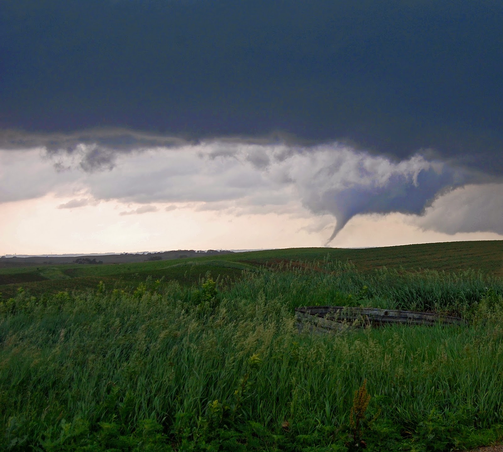
Last tornado of the day near Jackson, NE
Monday, July 14, 2014
6/14/14 Central Nebraska Moderate Risk Chase
Another chase, another moderate risk in Nebraska! My string of higher risk chases continued again on this chase as another moderate risk was issued for most of central and eastern Nebraska. For this day, a triple point was forecasted to set up in central Nebraska where storms would fire along near a dryline, warmfront, and cool front intersection. I picked Grand Island as my initial target and headed west from Omaha early in the afternoon.
I arrived around 4pm and waited at the big truck stop along I-80. There were many other chasers there and I milled around the big store inside waiting for initiation. Finally around 530, cumulus clouds began to bubble up. Initiation!!
The other chasers took off and I watched the radar looking for where the best storm would take shape. A few small storms finally formed and were moving off to the northeast north of Grand Island. I followed them northeast on Hwy 30 and then north on Hwy 14. One of the storms became the dominant cell and began to race of to the northeast though at 60 mph. The storm "left behind", just kind of pulsed for a while weakening and strengthening. I went north through Fullerton and then east a ways on Hwy 56 briefly entertaining the thought of trying to catch up with the storm that was racing away from me. I gave up on that storm and found a spot to pull of the road on Hwy 56 to watch the storm back to my southwest still south and west of Fullerton.
The storm became more and more organized and soon I knew that would be the storm for me to watch. I moved into position to get in front of it heading back south and east on Hwy 39 eventually stopping several miles north of Silver Creek. The storm was back to my southwest and tried a few times to produce a wall cloud in the precip free base of the storm. Lightning was also very sharp and I didn't feel safe getting out of the car to take any pictures. After a good 15 minutes or so I dropped further south and soon a tornado warning was issued!
I pulled off the road where a few other chasers were and had a pretty good view of the back of the storm. For a brief while a pretty good rotating wall cloud formed and you could even hear the excitement from the other chasers as the optimism of a possible tornado forming was increasing. Fairly quickly though, the wall cloud dissipated and the storm moved off to the northeast and weakened.
At this point there were no other real impressive looking storms so I headed on home.
Day 2 outlook highlighting moderate risk again across Nebraska
Day 2 probabilities of severe weather
Day 1 11:30 am outlook continuing moderate risk across Nebraska and into western Iowa now
Day 1 hail outlook at 11:30 am
Day 1 tornado probabilities
Day 1 wind probabilities
Initiation! Cumulus clouds growing rapidly near Grand Island
small wall cloud forming
sunlit storm still strengthening
large wall cloud briefly formed and then dissipated
first storms finally forming just before 6pm
Severe warned storm at 720 pm. I'm the white circle just to the right of the red box
tornado warning finally issued at about 725!
Thursday, June 26, 2014
6/3/14 High risk company chase in Nebraska
After a fairly quiet period since Mother's Day, the weather finally started picking up. I went out chasing on 6/1 and even though didn't see a lot, it was still nice to get out again. After that chase my eyes were already on the next potential chase and it looked like it would be a potentially huge day severe weather wise right across Nebraska.
Sure enough the SPC issued another moderate risk across Nebraska and into Iowa. A warm front was forecast to lie across the states, setting the stage for another similar set up to the Mother's Day outbreak. Besides tornadoes and very large hail, there was also talk of a derecho, which is a long lived line of very strong wind producing storms. Some of the wording out of the local weather offices was very concerning. The set up was potentially even more explosive than the outbreak on Mother's Day when several strong tornadoes touched down along with large hail, wind, and flooding rains.
This day's set up the offices talked of baseball or larger hail, strong tornadoes and wind over 70 mph!
Derek, Mike, and I wanted to make sure we were in position plenty early, so we left town early with an initial target of Albion, NE. We leisurely made our way west throughout the late morning. Meanwhile, an early morning storm that had formed around daybreak in southwest South Dakota continued trekking east/southeast just across the border into northern Nebraska. It gained strength throughout the morning and soon was warned for 100 mph winds and golf ball sized hail in north central Nebraska!
We briefly entertained the idea of heading north a bit to get a good look at the storm as I am sure it had some amazing structure, but decided to stay south of it. Eventually the storm started to head southeast and towards Omaha. Almost the entire time it was warned, it was warned for baseball sized hail and 70-80 mph winds. Reports coming in usually confirmed this as it moved through Norfolk and several other smaller towns.
Blair was soon the next town in the storms path, and the town was absolutely destroyed by the very large hail and high winds. The Woodside car dealership had several thousand cars damaged or destroyed with damage estimated at 10 million dollars! The courthouse was severely damaged. Other houses and vehicles were damaged as well and there were over 2 dozen minor injuries in Blair. The storm moved southeast from there just clipping northern Omaha and the airport. Winds and hail continued on into Iowa and the Omaha airport was closed for several hours.
Meanwhile back to the west, we continued to drift west, while I watched the radar for signs of initiation. Some of the severe indices were off the chart as well! Finally around 3 pm, the first returns showed up on radar near Burwell and Taylor Nebraska. We were only about 20 miles away! The storms slowly grew and became more organized until finally a dominant cell formed west of Burwell. It soon showed very large hail and developed a hook echo!
We made our way to get into a good position to try and see the base of the storm. It became as dark as night as we got closer to the storm. A tornado warning was issued! We made our way west out of Burwell on highway 91. We couldn't see a wall cloud or any real strong rotation, but the storm looked so mean! The storm while it was organizing was pretty much stationary, but as we pulled up to it, it started it's forward motion at 45-50 mph.
We soon realized we had to get moving back to the east away from the storm. We went back to Burwell and then southeast towards Ord. One thing that was immediately odd was that the tornado warning box which showed up on my radar program was quite a ways south of where the storm was on radar and the storm was moving east.
We made it down to just outside of Ord and got out of the car to look at the storm behind us. According to the radar the storm should have been several miles to the north of us, but instead was almost on top of us again! In fact it was raining almost right away where we were and the radar showed no precip should be falling at our location. We again jumped back into the car and continued heading southeast down Hwy 11. Eventually, we made it to Hwy 22 which went east to Hwy 281. Reports of a tornado on the ground were coming in but it wasn't possible to see as the tornado was rain wrapped.
We dropped south on 281a bit so we could keep heading east on 22. At this point the storm was still tornado warned and again on radar looked to be at least several miles north/northwest of us. As we headed east towards Fullerton Nebraska, we could see ahead quite a ways to the east. Soon I noticed a lot of blowing dust and dirt started to blow across the road in front of us from north to south. The wind was strong enough that the dirt was getting lifted into the air fairly high, and there was a lot of debris being blown across the road. I don't mind dirt and pieces of corn stalks but what became worrisome was there were groves of trees along the north side of the highway and soon decent sized branches were getting blown down. I was worried that something bigger could come down. A few times visibility went down to several feet for a brief few seconds. Winds were estimated at 60-70 mph. It was a little nerve racking and again surprising because the storm looked to be quite a ways away from us on radar still.
We made it to Fullerton and headed south to try and get even further south of the storm. We hadn't made it more than a couple of miles outside of town when again we noticed a lot of dust being picked up in the fields to the west side of the highway in front of us to the south. Only this time, what really peaked my interest was that there was a pretty broad area of rotation out in the field and the dust was rising pretty quickly. Up in the clouds was a pretty noticeable area of rotation. A tornado was forming right in front of us, not more than a couple of hundred yards away from the road! At this point I had the choice of slowing down and letting the circulation pass the road in front of us or try to beat it across the road. The tornado was weak and moving fairly slowly to the east so I thought it would be best to try and beat it across the highway. I didn't want to stop where we were because I was worried about the storm approaching us at 50-60 mph that was warned for baseball hail and 70 mph winds.
As we moved south down the highway dust was blowing from west to east across the road, but soon inflow winds developed near the circulation/weak tornado and winds were now screaming from east to west across the road, again with blowing dust and other debris from a nearby building.
We made it to the area of blowing dust that was the worst and suddenly visibility dropped to literally zero! I have been in blizzards and never seen visibility this bad. What was so scary about this was being on a highway, only able to drive about 5 mph tops, and not knowing if someone is going to come flying up from behind and slam into us. Also, there was a truck in front of us that went into the dust storm first and we had no idea where it was.
The zero visibility lasted about 90 seconds to 2 minutes before we finally made it into the clear. We continued on to the next east west road and initially made an attempt to go east only to see blowing dust was already approaching the road in front of us. At this point, I decided to call off the chase, as the radar still wasn't accurately showing the very dangerous storm, the storm if it was producing a tornado, it was rain wrapped, and the storm motions were 50-60 mph.
We dropped down to I-80 at York and headed east towards Omaha. This entire time storms kept forming and were heading east over the same areas north of the warm front that ran from north central Nebraska southeast to just south of Omaha and into Iowa. The Omaha Eppley airport reported over 5" of rain and there was flash flooding in northeast Omaha. The last storm we ran into was a severe storm that crossed I-80 near Ashland. It had reports of golf ball to baseball sized hail and we were just behind it so we didn't run into any of that.
After all the storm reports came in there were only a handful of tornado reports, and only a couple of confirmed weak tornadoes. Most of the storms and especially the main, big storm that we were chasing ended up being a bit elevated as they were just too far north of the warm front. However, there was a ton of large hail reports up to softball sized and lots of high wind reports as well.
I posted a question on a chasing blog that I frequent asking if anyone else had issues with the radar program that I use. Other users of the same radar program also said they had similar problems with the radar not matching up with what the storm was doing and where it was located. I haven't heard any reasoning for why this happened.
storm reports from the day- Nebraska was the place to be!
day 2 outlook- already a moderate risk
day 2 probabilities
Day 1 outlook at 1130am
hail probabilities
tornado chances- 10% hatched area for possible strong tornadoes
wind probabilities
radar image of the storm we were chasing taken from around 4pm
tornado warned storm we were chasing now about 6pm
first storm developing north of Ord
the main storm as we approach it west of Burwell
the tornado warned storm made it dark as night at 4pm
the storm still tornado warned but not able to see the tornado
Mike, Derek, and I stopped for some pics after the first time driving through the high winds and blowing dust
My customer Derek taking pics of the storm after our 2nd close call. You can see the blowing dust out in front of the storm on the right hand side
Pic of the tornado as it was starting to form just off of the highway in front of us!
Subscribe to:
Posts (Atom)