Originally, this day didn't look like much of an opportunity to chase. The instability and best chance of storms was going to set up way down in eastern Kansas, Missouri, and Oklahoma. I didn't check the computer models for a few days, but decided to check them on Friday at the noon update. They looked impressive! Lots of parameters were pointing to a potential tornado outbreak on Sunday across Nebraska and Iowa!
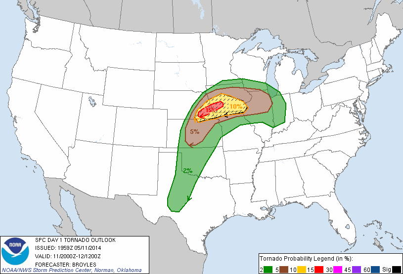
On the day 2 outlook that came out Saturday for Sunday's setup, the SPC upgraded the risk to a moderate risk with the discussion of potentially strong, long track tornadoes. The only worry was whether morning thunderstorms that were forecast to develop on Sunday morning would ruin the instability across the area.
Sunday morning I awoke to the expected thunderstorms. Some were severe with large hail across south central Nebraska and moved east across Nebraska into Iowa. At my house, I received .8" of rain.
Now it was time to hope the clouds would burn off and allow the sun to come out and create lots of instability. There was a warm front across northern Kansas that would be trying to lift north and where that front set up would be important for where the strongest storms would be. Slowly the clouds started to clear and move out throughout the late morning, especially in south central Nebraska and through the early afternoon in eastern Nebraska.
I had planned on heading out with a friend Mike, by 1-130 and head southwest towards Hastings, Nebraska. We left a little later than planned heading west around 200.
By 245, a tornado watch was issued for most of south central into eastern Nebraska. At 300, the SPC increased their odds for tornadoes and said in their outlook that there was a pretty good chance of a strong long track tornado from west of Lincoln through Omaha and into Iowa. The first cell formed south of Hastings and slowly strengthened. I was unsure if that would be the storm of the day and continued to watch and wait for something to form further east. We made it to York and headed south, making it to Geneva, Nebraska, and then headed west towards Clay Center.
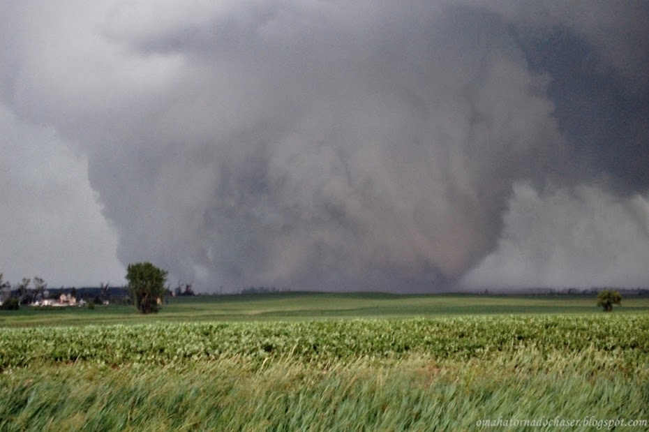
We approached the storm and suddenly it came into view. From the very beginning this storm was visually amazing. Our first view of the storm provided us with lots of blowing dust and gustnadoes across the open fields. The sky was dark and swirling like crazy back in the storm.
The RFD from the storm soon overtook us with strong winds and we headed east. The storm itself was heading northeast so we had to find a way to stay close to it and move northeast with it. That meant trying to navigate the gravel roads. The roads though weren't that good from the rain that fell earlier in the day. We tried to use them but kept coming across roads that were too muddy to even try so we eventually made our way back to Hwy 81 just south of Fairmont Nebraska.
As we approached Fairmont from the south things got pretty crazy for a while. The storm was to our north and northwest and had had reports of tornadoes on the ground for quite a while, but we couldn't see any of those due to them being rain wrapped. We came up to the intersection for Hwy 6 at Fairmont and started to get blasted with RFD winds again. Mike looked to the east and suddenly saw a tornado off in the distance! This tornado was a surprise as it wasn't back in the main hook of the storm. He snapped a couple of pics before it disappeared. There was some debris blowing across the road and part of a gas station sign was ripped off.
We turned east on Hwy 6 looking for the tornado but it was gone. We got into some rain and the rain curtains kept changing directions as we drove east through Exeter and Friend! This is a sign of strong rotation directly above us.
Meanwhile the meanest part of the storm kept producing tornadoes as it moved by Cordova and Beaver Crossing heading towards I-80. Hwy 6 turned north towards the interstate so while the storm was moving east and northeast it was now gaining on us. I kept a close watch on the radar and now there was a report of a tornado near the interstate and it was moving due east now.
The scariest part of our chase occurred next as we came up to the Milford exit on I-80. The winds started screaming again from the west as the RFD started to blast us. There was again debris blowing across the road and some small branches flying through the air. The car was kind of hard to control as the winds blew across us. Right before we approached the exit I looked to the west and in the heavy precip core to our west, there appeared to be a darker column that could have been a tornado. We got to the interstate and blasted east. Shortly thereafter, there was a report of 90 mph winds at the exit!
We went east to Lincoln and went north and there had a good view of the storm to our west/ northwest. Here the storm was probably the coolest looking storm I've ever seen. It had an amazingly long inflow tail and the sky had shades of green in it.
We dropped back to the interstate to continue heading east/northeast. The storm was now becoming more "messy", and had no real hook to it and the best areas of rotation kept changing but were always imbedded in the rain and hail. We made more attempt to go north to get closer but had to turn around as the storm beat us to the highway we were heading north on.
Back on I-80, the storm started producing crazy cloud to ground lightning. We even saw several strikes hit radio towers off of the road. The storm continued on towards Omaha and the western suburb of Elkhorn. It was weakening however and soon was "only" severe warned for some hail and wind. No tornado warning was active. Soon thereafter though a tornado warning was issued and this included western Omaha.
Mike and I were now on Hwy 31/204th street heading north towards Elkhorn. The storm started to overtake us and the rain and wind was coming down hard. I was still watching the radar though and soon noticed an area of rotation west of Elkhorn. I decided to stop to let the storm move past us. After waiting for the rain and wind to let up we continued north where we started to run into some damage done to trees and road signs near Elkhorn. We continued home and everything was okay at my house, but the neighbors lost a smaller tree.
There was reports of some much more significant damage to areas in Elkhorn and the NWS has come out with a damage survey that shows 2 tornadoes touched down in Elkhorn. The 2nd tornado actually went about 2 miles northwest of our house! Wind gusts across most of the central and northern half of Omaha were 70-75 mph. An 82 mph wind gust occurred at the Omaha Eppley airport! At one point there were almost 24,000 people without power in the Omaha area.
At the time of this writing there is believed to be 11 tornadoes across south central into eastern Nebraska with a couple of the tornadoes rated EF-3.
Overall, this was a pretty fun chase with an amazing long lasting supercell. I wish we could have seen more tornadoes but again they were all mostly rain wrapped.

Day 2 outlook

Day 2 outlook probabilities

Day 1 3pm outlook

Day 1 3pm hail probabilities

First tornado warning near Clay Center. I am the white circle under the purple line.

Tornado warned storm approaching Beaver Creek. Severe damage would later occur in Beaver Creek.

Tornado over Beaver Creek. Again I am the white circle under the red box towards the bottom.


Storm as we first approached near Clay Center, NE

more shots of the storm as it moved northeast across south central Nebraska


several areas of rotation on the HP storm


storm northwest of Lincoln. one of the coolest looking storms I have ever seen!

again

ground scraping inflow cloud into the storm!
The storm produced some heavy rainfall totals across most of eastern Nebraska. Some totals up to 7" were reported. Here at my house, my rain gauge measured 2.73" of rain

I will post some video once I get it uploaded. Here are some other clips of videos taken by other chasers on this storm.
Damage surveys from Omaha and Hastings: