I arrived around 4pm and waited at the big truck stop along I-80. There were many other chasers there and I milled around the big store inside waiting for initiation. Finally around 530, cumulus clouds began to bubble up. Initiation!!
The other chasers took off and I watched the radar looking for where the best storm would take shape. A few small storms finally formed and were moving off to the northeast north of Grand Island. I followed them northeast on Hwy 30 and then north on Hwy 14. One of the storms became the dominant cell and began to race of to the northeast though at 60 mph. The storm "left behind", just kind of pulsed for a while weakening and strengthening. I went north through Fullerton and then east a ways on Hwy 56 briefly entertaining the thought of trying to catch up with the storm that was racing away from me. I gave up on that storm and found a spot to pull of the road on Hwy 56 to watch the storm back to my southwest still south and west of Fullerton.
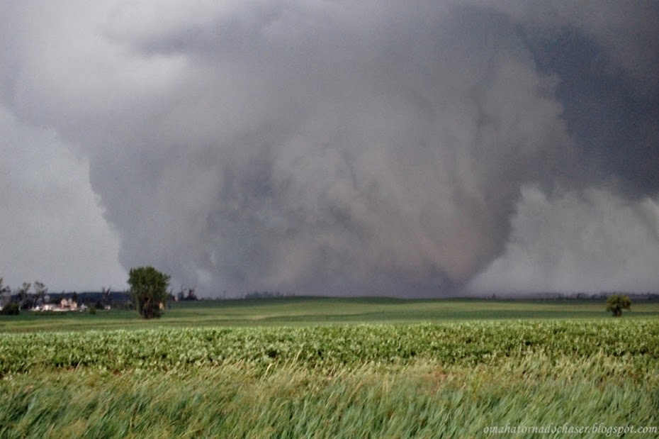
The storm became more and more organized and soon I knew that would be the storm for me to watch. I moved into position to get in front of it heading back south and east on Hwy 39 eventually stopping several miles north of Silver Creek. The storm was back to my southwest and tried a few times to produce a wall cloud in the precip free base of the storm. Lightning was also very sharp and I didn't feel safe getting out of the car to take any pictures. After a good 15 minutes or so I dropped further south and soon a tornado warning was issued!
I pulled off the road where a few other chasers were and had a pretty good view of the back of the storm. For a brief while a pretty good rotating wall cloud formed and you could even hear the excitement from the other chasers as the optimism of a possible tornado forming was increasing. Fairly quickly though, the wall cloud dissipated and the storm moved off to the northeast and weakened.
At this point there were no other real impressive looking storms so I headed on home.

Day 2 outlook highlighting moderate risk again across Nebraska

Day 2 probabilities of severe weather

Day 1 11:30 am outlook continuing moderate risk across Nebraska and into western Iowa now

Day 1 hail outlook at 11:30 am

Day 1 tornado probabilities

Day 1 wind probabilities

Initiation! Cumulus clouds growing rapidly near Grand Island

small wall cloud forming

sunlit storm still strengthening

large wall cloud briefly formed and then dissipated

first storms finally forming just before 6pm

Severe warned storm at 720 pm. I'm the white circle just to the right of the red box

tornado warning finally issued at about 725!
No comments:
Post a Comment